
Hiking in Beautiful Sedona
- Apr 30, 2024
- 17 min read
Updated: Jul 21, 2025
All photos taken by lotzacurls

Sedona, Arizona is one of the most scenic hiking areas in the United States. Its multi-hued rocks, dry air, and cacti-studded deserts make it a mecca for anyone looking to stomp their hiking boots onto the dirt.
Since I was hiking solo, I chose busy trails in case I needed assistance; the safety-in-numbers thing often applies in hiking. The most popular trails are very well-indicated and easy to follow. I was never alone for longer than a few minutes.
The biggest frustration I encountered here, just as I do back home, is sharing nature with people who... well, don’t know how to share nature.
Frankly, if you don't know how to avoid leaving garbage on the trail, we’d all rather you stayed home. Wear proper footwear, dress appropriately for the weather, and bring extra layers and food/water in a bag, especially if you’ve got kids. And for everyone’s sake, bring doggie bags, use them and carry them out with you when your pets decorate the trail.
Seven principles of Leave No Trace:
Plan ahead
Stay on the trail
Pack out what you bring
Leave areas as you found them (or better)
Minimise campfire impacts
Be considerate of other hikers
Do not approach or feed wildlife.
I was lucky enough to spend five days hiking in Sedona, sometimes doing two hikes in one day (lots of half-day hikes here). Here is a breakdown of the trails I got to enjoy. Let’s go!
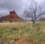
Fay Canyon (+ Fay Canyon Arch)

* Half-day hike, out-and-back. Wide, straightforward trail. No signage. Dogs must be leashed.
* Distance: Roughly 4 kms return (approx 2 hrs) Add extra time for arch.
* Elevation gain: 170 m (add 120 m for arch detour)
* Difficulty: Easy (Moderate to arch)
* Trailhead: Fay Canyon Trailhead parking lot, on Boynton Pass Road. Red Rock Pass needed.
This is easily one of the best bang-for-your-buck hikes in Sedona. No strenuous effort required; a pleasant stroll on a sandy path and a stunning view at the finish line. It's great for kids or beginners. I saw a lady walk it in straw platform heels.
The negligible elevation you gain from beginning to end is so gradual as to not even be noticed. The only effort comes at the very end when you decide how high to climb up the hill for your view, or even if you'd like to clamber up to the arch on your return trip.
Trail description - Fay Canyon
The trail begins across the road from the Fay Canyon parking lot, and consists of sandy dugouts as you approach a wide valley. This valley becomes narrower as you keep walking.

The wide trail meanders through forest. Keep following the obvious path. There’s not much to say here; just enjoy the serenity of the canyon, listen to the birds, breathe deeply.

About halfway (almost a km in), you might spot a small cairn in a ditch and notice a path going off to the right. This trail leads to Fay Canyon Arch.
You can see the well-camouflaged arch through the trees if you look closely. I most certainly did not see it on my way in (Or the cairn. Or the path.) and only thought about looking for the trail once I was returning.
Anyway, on to the end of the canyon.
At the end of the trail, you'll come face to face with a sloped wall. There are rocks and staircase-like grooves to assist in your ascent. Go up as far as comfort allows, find a place to sit, and admire the view down the canyon towards Sedona. This is an excellent spot to have a snack. You know what they say: Hiking is just an excuse to eat good food in cooler places.

Trail description - Fay Canyon Arch
Heading back, keep your eyes open for that cairn and the path, which will now be on your left.

The path up to the arch is trickier than the one to the end of the canyon. It is rocky and steep for the entirety of its 120 m, but it’s completely doable - I was joined up there by a heavily pregnant woman.
Also, watch out for the cacti!!! I happened to lose my balance right at the moment where I had a big cactus on either side of me - I'm still pulling out little spines from my thigh and my thumb one week later. Not kidding,

I've read that this is one of the most beautiful arches in the area. Parts of it are only a few feet from the rock wall behind it, so it is almost freestanding. It's actually large enough to be difficult to capture within a single photograph, being almost 30m wide and soaring at least 4m above your head.
Once you've had your fill of the grand views, head back down the steep path and turn left toward the parking lot.
Courthouse Butte / Bell Rock Loop

* Half-day hike, loop. Wide, straightforward trail. Well-signed. Dogs must be leashed.
* Distance: Roughly 6 kms (approx 2-2.5 hrs)
* Elevation gain: 120 m
* Difficulty: Easy (but rocky and possibly very muddy)
* Trailhead: Courthouse Vista parking lot, off Red Rock Scenic Byway (route 179). Red Rock Pass needed.
This is a great, mostly flat hike for anyone wanting superb views of two of Sedona’s most iconic mounds: massive Courthouse Butte and the smaller, fun-shaped Bell Rock.
Note: This is a chilled-out trek around the base of both Courthouse Butte and Bell Rock; you don’t climb up the mountains themselves. If that's what you want, see below for a description of the Bell Rock Climb.
If the parking lot is full (as it may very well be), try parking at Bell Rock Pathway Trailhead, the next lot south on the 179. You’ll catch the same loop from a more southernmost point.
Trail description
I did this trail in a clockwise direction. There are lots of rock cairns in wire baskets and signs at every junction, so it’s hard to get lost. Just keep Courthouse Butte and Bell Rock to your right at all times (or to your left if you’re going counter-clockwise) and it’ll be a cinch.
From the parking lot, take the Bell Rock Access Trail and go left at Courthouse Butte Loop. Take the Llama trail for a bit then rejoin the Courthouse Butte Trail.

You’ll get great views of Sedona as you walk North of Courthouse Butte. You should be able to spot the iconic Chapel of the Holy Cross and Cathedral Rock.
Keep making your way around Courthouse Butte for great views of the Munds Mountain Wilderness ranges.

As you round the Southern end of Courthouse Butte (about 3 kms in), you’ll come to a large washed-out area. The trail name changes to Big Park Loop here, and signs indicate that you can either stay on this more southern path or cross the wash for the northern Big Park Loop that hugs Courthouse Butte more closely. Take that one; cross the wash to get closer to the mountain and continue on the North part of Big Park Loop. (It sounds confusing, but I promise that it’ll be clear once you get here.)

Stay on Big Park Loop through the coming junctions (again, check out the signs). You’ll be walking toward Bell Rock and will probably be able to spot some people clambering onto it.
After almost 5 kms, the trail changes back to Bell Rock Pathway; follow it back to your starting point.
If this is too long of a hike for you, you can always circle just Courthouse Butte or just Bell Rock (there is a trail that passes between both mountains, so you can do them separately). I’ve heard of people hiking a figure eight around / between both of them.
Base of Bell Rock only: Bell Rock Loop (10Adventures)
From your starting point, decide if you’ve had enough or if you'd like to climb Bell Rock (see below). It’s fun and the views are amazing!
Bell Rock Climb

* Half-day hike/scramble, up and back down. Trail signed at beginning, free scrambling afterwards. Dogs and small children permitted, but not recommended.
* Distance: Roughly 1,5 kms return (approx 2 hrs)
* Elevation gain: You decide! Up to 120 m.
* Difficulty: Moderate (third-class scrambling) Don’t be afraid to use your hands!
* Trailhead: Courthouse Vista parking lot, off Red Rock Scenic Byway (route 179). Red Rock Pass needed.
From the Courthouse Vista parking lot, follow signs to Bell Rock Climb. There are lots of wire rock baskets to guide the way in the beginning (first 0.5 km); afterwards, you are free to find your own route as your comfort levels dictate.
You can’t make it all the way to the top of Bell Rock without ropes, but you can get pretty high. You’ll need to use your hands (and use your head!) Wear hiking shoes that have good traction and that ‘stick’ to the rock.

Remember that coming down is always more treacherous than going up; I saw plenty of people who got stuck like a cat in a tree and needed to be coaxed down or helped.
There are countless places to sit and enjoy the views. Remember that the path back down faces Sedona and Cathedral Rock. If you’re facing Courthouse Butte or another mountain, you ain’t in the right spot to come back down!
Baby Bell Rock
* Quarter-day hike/scramble, up and back down. Trail signed at beginning, free scrambling afterwards. Dogs and small children permitted, but not recommended.
* Distance: Roughly 1.5 kms return (approx 1 hr)
* Elevation gain: You decide! Up to 50 m.
* Difficulty: Easy (+ short, second-class scrambling) Use your hands!
* Trailhead: Courthouse Vista parking lot, off Red Rock Scenic Byway (route 179). Red Rock Pass needed.
This short and spectacular hike is an unofficial trail. I preferred it over Bell Rock, as it was much less crowded (I had it to myself!) and the 360-degree view from the top was magnificent. It’s very doable and most people will consider the scrambling far less intimidating than on Bell Rock.
Trail description
Start from the Courthouse Vista parking lot and take a left onto Phone Trail. The trail winds around the base of the mount, increasing slightly in elevation. Eventually, the trail leads up and off to your right. After a while, you’re free to scramble over the rock and find your ideal way up and back down.
I’ve read that you can also follow the Bell Rock path until you are in between Baby Bell and Bell Rock, then a trail on your left leads up to Baby Bell. I can’t attest to it, as it’s not the path I took.


I also really enjoyed seeing the imposing range of the Munds Mountain Wilderness rearing up next to me. All in all, this trail was the icing on the cake after a day filled with awesome hiking.
Brins Mesa & Soldiers Pass Loop

* Full day hike, loop. Trail signed throughout. Dogs must be leashed.
* Distance: Roughly 9-10 kms (approx 3-4 hrs)
* Elevation gain: Roughly 365 m
* Difficulty: Moderate/intermediate
* Trailheads: Brins Mesa/Jim Thompson (at end of W Park Ridge Drive, which requires Red Rock Pass) or Soldier Pass parking lot.
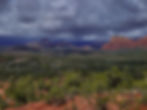
Just minutes from Uptown Sedona, two of the region’s most beautiful hikes can be linked without adding much extra mileage. Whatever energy you would have been spending heading back down the same trail will now be expended by looping and going down the next valley over. Two spectacular trails and valleys in one day - you can’t lose, baby!
So which trailhead should you use? I started this (counter-clockwise) loop at the Jim Thompson trailhead; parking is much easier to find there than at the Soldier Pass Trailhead (50 cars vs 15 cars). But be warned, the road getting here is short but rough, although doable in a small sedan at slow speeds. I wouldn't take my chances with a camper van or trailer; your Smart car may very well fall straight into the potholes. There are toilets, as well as a machine to purchase a pass (no toilets at Soldiers Pass parking lot). The Jim Thompson lot is also open 24 hours a day, but the Soldier Pass lot closes at 6pm; once the gates are locked, your car will be sleeping overnight in that car park. So… Jim Thompson trailhead strongly recommended.
However, you can use the fantastic and free Sedona Shuttle to get to Soldiers Pass. There is free and plentiful parking where you catch this shuttle.

Trail description
You will be taking four trails on this loop: Brins Mesa, Soldiers Pass, Jordan and Cibola Pass. Brins Mesa starts out rambling on a wide path through Mormon Canyon; it’s pretty easy going, even once the altitude kicks in.
There are lots of boulders that act as makeshift stairs, and numerous switchbacks make the climb less arduous than it ought to be. Turn around periodically to enjoy the view or to catch your breath. The trail is straightforward and obvious throughout.
After about 1.5 hours (at 3 kms), you’ll climb up onto the mesa, a flat-topped swash of sand, brush and cacti that affords 360 views. If you continue right along the ridge, you can follow a faint trail through the scratchy brush (about 1.5 kms extra one-way) all the way up a green hill that actually hides a rock crop offering incredible views of the surrounding towers.

Back on the original trail, continue straight (northwest), then curve left and around some large boulders over the next km in order to pop onto the top of Soldiers Pass Valley (the next valley over.) You’ll start losing altitude once you’re there, and what sweeping views you’ll get over the next km!
Stop to gaze at the scenery (it’s easy to miss it when you’re constantly checking your footing) but be cautious; there are plenty of cacti just waiting to stick their spines into your shins.

If you wish, you could hop onto a side trail to see Soldiers Cave. I didn’t go, but information on how to find it is abundant online. The unmarked trail is relatively obvious; look for it on your left, not long after a sign marked Red Rock/Secret Mountain Wilderness. (A National Forest Wilderness sign is also tacked to a tree on the actual Cave trail). The walk to Soldiers Cave adds an extra km and is mostly steep uphill.
About 1 km past the trail to Soldiers Cave comes the Seven Sacred Pools, small pockets in the rock that fill up with water after rainfall. I don’t have photos for you, as it was underwhelming due to lack of, well… pools. It can get pretty dry here, I suppose.
One km after the Seven Sacred Pools, you’ll come across Devil’s Kitchen, a sizable sinkhole that has collapsed a few times recently. Do not head down the hill facing the sinkhole; that’s a 4x4 road. Go left and walk across the front of Devil’s Kitchen until you see the sign for Jordan Pass on the wash.
Jordan Trail is short (0.5 km) and mostly flat; you’ll soon come to a sign indicating Cibola Pass Trail.
Cibola Pass Trail is a little less than 1 km long but it’s a lot of uphill, which might feel a bit daunting after a day of hiking in the sun. You’ll head downhill soon enough and break through the trees to the parking lot. Kick off those shoes and dust your ass off!

Don’t forget Sedona at sunset; there are a number of places to go to catch the sun setting on these beautiful rocks.
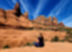
Subway Cave (via Boynton Canyon)

* Half-day hike, out-and-back. Trail signed for Boynton Canyon hike, but not for Subway Cave. Dogs must be leashed.
* Distance: Roughly 12 kms (approx 4 hrs)
* Elevation gain: Roughly 335 m
* Difficulty: Easy for canyon / Moderate to challenging for cave
* Trailhead: Boynton Canyon Trail parking lot (off Boynton Canyon Rd). Parking on road permitted, but Red Rock Pass still required.
Boynton was the busiest hike I did in Sedona; it generally comes third after Cathedral Rock and Devil’s Bridge. It is a mostly flat trail with some shaded areas (a welcome respite even in April!) and two interesting side jaunts: Boynton Canyon Vista and Subway Cave.
Just like Fay Canyon, the trail ends at the back of the canyon with an imposing wall rising above the trail. Climb up for views all the way down the canyon. Retrace your footsteps back to your car or shuttle.
Trail description
The wide and sandy trail starts at the large sign in the parking lot and is very well-indicated.
Near the start of the hike (o.5 kms in), the Boynton Canyon Vista path goes off to the right and leads up to some interesting chimney rocks. It’s supposed to be moderately strenuous up to the top and represents a roughly 45-minute detour. I somehow totally dismissed this off-trail on my way in (I was excited to get to the cave) and again, somehow didn’t feel like visiting on my way back, which I now regret. Sunlight was fading, and it would have made for a blissful, colourful sunset. I have no excuse; I was carrying a headlamp and could easily have made the trek back to the car. Bummer.
The trail becomes rockier, strewn with boulders and stubby trees, as you continue a few kms in. The views are typically beautiful, surrounded by dramatic red rocks.

The junction leading toward Subway Cave is just over 3 kms into the hike, but it’s easy to walk right past it. There is a large tree on the left and a fairly ‘open’ area in the forest on the right. There was a large bunch of sticks indicating the path when I was there, but nothing permanent. Either way, the trail is narrow but distinctive if you’re looking for it. Follow it uphill for about half a kilometre.

To get up and into the mouth of Subway Cave, you’ll have to either shimmy up a narrow passage (on your left when looking toward the cave) or, if your shoes are sufficiently sticky, clamber up the steep sandstone chute next to it (on your right when looking toward the cave).
This will also be your route back down, so keep that in mind if you’re squeamish about heights. Or about sliding down rock chutes.
Walk up to the back of the cave and turn around. This will be your view.

You can walk along either ridge inside the cave, although the left side is wider and more even-grounded. I have a fear of falling and did not walk on the right ridge, where you could curve around a narrow bend (with a vertiginous drop-off) and keep walking to the Sinagua ruins. Apparently, there are all kinds of neat spots to explore up there. But be respectful, peeps.
To get back down, I tried sliding down the middle of the chute on my bum, but it is actually fairly steep and really icy (shiny and slippery from overuse), with nothing to stop your ride. I totally saw myself slamming into the rock below, and suddenly understood how all those cats feel, the ones that get stuck way up in the trees? Yeah.
Then I remembered a trick I learned during rock climbing (Smearing!), and I placed both feet on each 90-degree ‘ledge’ (both sides of the lower left chute) and shimmied my way down on my bum while pushing on the ledges with my feet and hands. Piece of cake. Felt stupid afterwards, having envisioned myself sleeping in the cave overnight for fear of coming down.
Trace your footsteps back down to the main trail, and turn right to continue to the end of Boynton Canyon. You have about 1.5 kms to go, with some uphill to tackle for the final climb.
Follow the main trail back to the parking lot once you’ve had your fill of beautiful views. Don’t forget to add (and don’t dismiss) Boynton Canyon Vista on your way back.
Broken Arrow Loop (w/ Chicken Point + High on the Hog + Twin Buttes)

* Half-day hike, lollipop loop. Trail well-signed throughout.
* Distance: Roughly 4.5 kms (approx 2-2.5 hrs)
* Elevation gain: Roughly 95 m
* Difficulty: Easy/Moderate
* Trailhead: Broken Arrow parking (at end of Morgan Road). Red Rock Pass required but no machine (buy online).
When I met a few locals on the Brins Mesa trail, I asked them about their favourite hikes in the area, and Broken Arrow came highly recommended. Many people avoid it because it's popular with both mountain bikes and off-road 4x4 vehicles, but don’t let that sway you. I was largely unbothered by them (although I could hear them) and I was visiting Sedona at a very busy time of year. Keep in mind that this hike is largely unshaded.
Loop overview: From Broken Arrow trailhead, I trekked to Chicken Point Overlook. Came back down Broken Arrow trail until a junction where I headed left onto High On The Hog. At the junction to Twin Buttes, I went right (mostly downhill) and followed Twin Buttes trail all the way back to Broken Arrow Trail, then to the parking lot.
Trail description
From the parking lot, cross the Jeep road to find the trail. It will head left and slowly climb uphill. You’ll come to an open area where you can continue left onto Broken Arrow or right on High on the Hog. Since you’ll come back to this crossroad later, go left towards Chicken Point Overlook (about 2.5 kms from parking lot).
Once you’ve had enough of the awesome views at Chicken Point Overlook, retrace your steps to that earlier junction and continue onto High on the Hog.

You'll follow just a brief section of High on the Hog, and it skirts a ridge. It’s not precipitous or narrow, but those who aren’t comfortable with heights might not want to dance around. Watch out for bikes which will be travelling much faster than you.
At the next junction, don’t get onto Hog Heaven; you should be going right on Twin Buttes.
The trail to Twin Buttes heads downhill; watch your footing. You’ll head down into a wide canyon and after a few kms, hook back up with the initial Broken Arrow trail you took at the beginning of your hike.
Hopefully you enjoyed this one as much as I did.

Doe Mountain

* Half-day hike (possible day hike), out-and-back. Very little shade. Leashed dogs OK.
* Distance: Roughly 2.5 kms (1.5 - 2 hrs, + more if you want to explore flat top)
* Elevation gain: Roughly 155 m
* Difficulty: Moderately strenuous, short class 2 scrambling, exposed cliffs
* Trailhead: Bear Mountain parking lot (on Boynton Pass Road). Red Rock Pass required (machine at trailhead).
This is a good quick hike if you’re looking for a good workout and great views. You can make it up and back down in an hour if you’re givin’ her.
Trail description
The trail starts at the parking lot (Bear Mountain hikers must cross the road). You’ll soon start climbing long switchbacks, which make the steep ascent more accessible.
The main path veers right before heading into a long switchback to the left that will scale almost the entirety of the front of the mountain. You’ll have to scramble across some flat rocks at one point but the trail is usually fairly obvious.
Near the summit, before breaking onto the flat top, you might have to use your hands again to scramble over the short rock walls.
Once on the flat top, take your time to explore the views. This is the highest point around (excepting Bear Mountain), so the views are unimpeded. It’s hard to get lost as the mountain is almost a crescent shape, but it’s not fun to go off-trail and run into all that cacti (and there is a TON of cacti up there).

Stick to the footpaths that braid all over the flat top. When you’re done, head back toward the inner part of the crescent to find the path back down to the parking lot.


So there you have it, folks! My next trip to Sedona will surely include the immensely-popular Devil's Bridge and Cathedral Rock hikes, but I wasn't willing to fight for a parking spot there, when so many other beautiful hikes were waiting to be enjoyed. And enjoy them, I did.
See you on the trails !