
My Favourite Hikes in Yoho National Park (So Far!)
- Oct 2, 2019
- 8 min read
Updated: Jan 18, 2024
I love this little park, tucked away just inside the Eastern border of British Columbia. It’s not anywhere near as huge as Banff or Jasper National Parks, but it packs a few hard-hitting punches with beautiful, scenic hikes and well-maintained trails.
Yoho National Park, although much smaller and lesser-known than its neighbour Banff National Park, is an absolute gem of a spot in which to find yourself. Yoho means amazement or awe in Cree, and it perfectly describes this tiny patch of land in my vast and beautiful country.
Make sure you purchase a Parks Canada Discovery Pass before coming out. Also, check the Government of Canada Trail Report for possible trail closures and warnings (you are in black bear/grizzly territory). Be prepared and equipped for a sudden shift in weather. Hike with others, bring your bear spray and don’t forget your hiking poles. (I do find them to be helpful, as I lean too far forward when walking uphill and they help my knees on the way back down. They also provide extra traction with steeper sections).
These are my personal faves in Yoho National Park. The best bang-for-your-buck hikes, where the rewards surpass (or at least match) your efforts. The times and difficulty levels are approximative; I’m in moderate shape and I exercise on a regular basis, so don’t take any of it for gospel. Just strap on your boots and get hiking!
Oh, carry bear spray and know how to use it!
Lake O’Hara
Trip 1 - Lake O’Hara Alpine Circuit 5-6 hours (or 2 days), 12 kms
Trip 2 - Lake McArthur and Big Larches Loop 3 hours, 7 kms
This stunning district offers hiking options ranging from easy strolls to a challenging, full-day hike along exposed mountain ridges. A visit here is best honoured with a multi-night stop, but take whatever you can get here, as booking an overnight stay (or even a seat on the shuttle bus) can be difficult.

The Alpine Circuit is the crown jewel of the Lake O’Hara region, but there are shorter hikes if you’re not up for the slog or if you’re limited in time.
The Alpine Trail becomes hazardous in stormy weather or snowy conditions; even in good weather, certain spots allow no room whatsoever for missteps.
1. Lake O'Hara Alpine Circuit (2-day trek described below)
Overview: At 10:30am, I took the first shuttle bus into Lake O’Hara (from the parking lot), and dropped off my backpack at Elizabeth Parker Hut, where I would stay for one night before taking the shuttle bus back the following afternoon.

I started the Alpine Circuit on Day 1 around noon and walked the northeast loop: Up Wiwaxy Gap, onward to Lake Oesa, and back via the East Opabin Trail (in blue).
My intended Day 2 hike would have taken me up the West Opabin Trail, around the All Souls’ Alpine Route, then finally to Lake McArthur before catching the last bus back to my parked car (intended route in orange). With only 2 half-days and one night’s stay, this seemed like the most efficient way to walk as many trails as possible.
However, foul weather ensured I would only hike part of Day 2's route (in yellow).
If you want to do the entire Alpine Circuit in one day, visit the AllTrails or Parks Canada websites.
Day 1 Loop: Wiwaxy Gap, Lake Oesa and East Opabin Plateau (5 hours, fairly challenging)

As mentioned, there are a few rocky ledges to traverse on your way up to Wiwaxy Gap. All are manageable in good weather if you're not squeamish about heights or exposure (which I actually am), but proceed with caution in bad weather. The path is wide enough to walk comfortably, but there isn't a ton of room for error. Be mindful of your walking poles or any backpack straps snagging on rocks and causing unbalance.
The first 2 kms of hiking, between the Lake O'Hara Lodge and Wiwaxy Gap, provide great cardiovascular training and the views are astounding - as good as views get in the Canadian Rockies.
Once you've made your way up to Wiwaxy Gap, know that the toughest part of the hike is behind (and literally, below) you. From here, you'll slowly make your way down a scree traverse to Lake Oesa, pictured below.

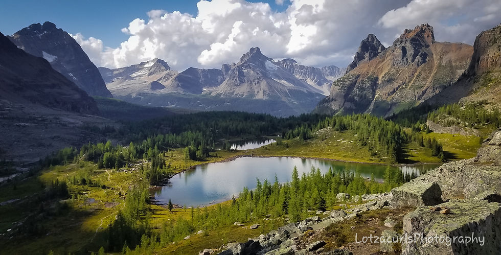
After Lake Oesa, you'll swing around the Yukness Ledge, strewn with large boulders. This rocky traverse is steep and will demand your full attention, and will eventually drop you onto the beautiful, green, lake-dotted Opabin Plateau, your reward for your hard work. If there is one hike in the Rockies that is worth the hard work, the Alpine Circuit is it!

As it was getting late, I headed down the East Opabin Plateau trail and back to Elizabeth Parker Hut via the Lakeshore Trail. I had completed the «northeast loop» (refer to map above) and was hoping to hike the «southwest loop» the following day.
Day 2 loop: Lake McArthur and Big Larches Trail (3 hours, 7 kms)

Hampered by uncooperative weather, I wasn't willing to sacrifice myself to the mountain gods by attempting All Souls' Trail in the thick fog and rain, which would make navigation trickier and obstruct views of the Lake O'Hara Basin, which was principally why I was there. So a quick jaunt to Lake McArthur via the High Route became my plan for the day (the Low Route is another option, but it does offer less stellar views).
Lake McArthur ended up being quite the beauty. Even though I certainly wasn't the only one there, I managed to find a very quiet spot to enjoy both my lunch and the views spread out before me.

I returned from Lake McArthur via the Big Larches Trail, which was lovely (in yellow on map). But I had really enjoyed the Opabin Plateau and its beautiful lakes the previous day; I had been looking forward to hiking its Western trail, as well as the All Souls’ Alpine route. Which is why I’ll be returning to Lake O'Hara one day.
Book some time at Lake O’Hara!
Quotas limit the amount of visitors to the Lake O'Hara region, and most of that quota is met by hikers with reservations at the following three accommodations:
Campground: A Wilderness Pass is required (as well as bus service) and must be reserved months ahead of time. Campground is located 0.6 km north of the lake. 403.343.6433 Parks Canada Campground info
Elizabeth Parker Hut: Year-round backcountry hut accommodations, managed by the Alpine Club of Canada. Reservations needed. 403.678.3200 www.alpineclubofcanada.ca
Lake O’Hara Lodge: Seasonal high-end accommodations, reservations needed.
403.343.6418 (in-season), 403.678.4110 (off-season) www.lakeohara.com
2. Iceline Trail
* Day hikes: Lower Loop via Celeste Lake (12 kms, moderate) or Higher Loop via Little Yoho Valley (21 kms, moderate)
* Overnight hike: Stay at Little Yoho Campground or Stanley Mitchell hut, with possible add-ons the following day (Twin Falls and/or Whaleback Mountain)


Regardless of which option you choose, you’ll have a decent slug up some switchbacks until you reach Emerald Glacier. Then at the 5.7km junction, the Lower and Upper Trails will fork off. The Lower Trail veers right and descends toward Lake Celeste; it boasts less elevation and will be easier on the heart and legs, but consequently won’t offer as many fabulous views. The High Trail veers left at the junction and gains more elevation over the Iceline Summit. It will take you through Little Yoho Valley, veer right at Laughing Falls, and pass Lake Duchesne before looping back down to your starting point.
For the overnight hike to Little Yoho Campground, take the Higher Trail to Little Yoho Valley and you’ll eventually run into Stanley Mitchell Hut. Little Yoho Campground is not far, just a bit further left of the hut.

As mentioned, the steep switchbacks lead up to a plateau dominated by the beautiful Emerald Glacier. Once you get past the treeline onto this plateau, it’s mostly smooth sailing.


Bombardment by dazzling sights is a natural pain reliever. Kathy and Craig Copeland

3. Twin Falls loop (via Little Yoho Valley and Marpole Lake)

* Day hike. Lollipop loop. Many signs, distinct path. Dogs must be leashed.
* Difficulty: INTERMEDIATE
* Distance: Roughly 19 kms return (5-6 hrs total)
* Elevation gain: Roughly 500m
* Trailhead: Takakkaw Falls parking lot on Yoho Valley Road (closed from mid-Oct until late June, off Hwy 1 near Field, BC)
If towering waterfalls are your thing, then Twin Falls is the hike for you! There are several ways to access these falls, but we chose to do a loop using the Marpole Connector. You can hike a more straightforward there-and-back path along Yoho Valley trail, or add extra elevation via the popular Whaleback Trail loop; both are routes you’ll easily find online. Since our route was a bit less orthodox, here’s a screenshot from my Strava account.

On the way to Twin Falls, you’ll pass a historic teahouse, a pretty lake, another waterfall (Laughing Falls is nothing to snicker at) and sweeping mountain landscapes. Not to mention the stunning drive along Yoho Valley Road to get here and back.
Twin Falls (via Yoho Valley Trail) is one of the best-kept trails in the park. This isn’t Kananaskis Country; expect it to be well-signed and well-maintained, but fittingly busy. The side road (Yoho Valley Road) off the main highway (Hwy 1) is closed from mid-Oct to early June. You can access it if you want to backcountry ski the entire thing; it’s 14 kms one-way and in avalanche country, so start training now.

TRAIL DESCRIPTION
The trailhead begins at the parking lot of Takakkaw Falls Campground. Most people pop in for an hour or so to gape at this huge waterfall and leave afterward, but the first-come first-served campground is worth staying in. Although considered a frontcountry campground, you have to walk in carrying all your gear (wheelbarrows are provided at the parking lot to help haul your stuff). It’s a 400-500 m walk (7-8 minutes) and worth the view of Takakkaw Falls alone.

Takakkaw means magnificent falls in Cree. And no, the water in this photo hasn’t been Photoshopped. Most glacier-fed waters in Western Canada are turquoise, due to the fine rock dust not settling at the bottom, therefore reflecting sunlight (or something of the sort – my apologies for the unscientific explanation).
You’ll pass Takakkaw Falls campground first thing along Yoho Valley trail and walk along a fairly unremarkable fire road. The going is fairly flat and uninspiring, but short detours line the way: Angel’s Staircase and Point Lace Falls at 2.2 kms, and Lake Duchesnay at 3.6 kms.
After roughly 4.5 kms, you’ll reach the pretty but possibly underwhelming (compared to Takakkaw and Twin Falls) Laughing Falls.

Leaving Laughing Falls, you’ll cross a foot bridge and pass Laughing Falls campground. Reach a junction and go right for Twin Falls (left leads to Stanley Mitchell hut). The elevation gain starts up around here, but it never gets too bad. Intermediate steepness only. Keep on trekking.
Most of this hike is pleasant enough, winding through old forest. It took about 3 hours (and roughly 8.5 kms) to reach the historic Twin Falls Teahouse from Takakkaw Falls.


The Tea House has been standing since 1908, originally built by the Canadian Pacific Railway as an overnight shelter for horseback riders. It was boarded up when we visited (Sept 2023), but hopefully one organisation or another will take over management soon.
Coming up is the stunning show-stopper section of the entire hike. Continuing past the Tea House, you can meander a bit off-trail through the trees and get your first glimpse of Twin Falls. You’ll notice a massive rock outcrop that can be climbed in order to get closer to the falls. As always, watch your footing and follow your instinct.

We continued on the Marpole Lake Connector, a trail that essentially traverses the flank of Whaleback Mountain as opposed to going over and around it; much less elevation to tackle. The downhill trail is rougher here but after about 10 minutes, you’ll reach Marpole Lake.

After Marpole Lake comes the boulder field, which will take about 2 kms (30 mins) to cross, over about 100m elevation gain. Route-finding might be a bit challenging here, as even looking back I couldn’t quite discern the trail I had just walked over. It’s all a bit Mordor-ish and bleak and definitely adds character to the hike.
Head downhill after exiting Mordor; at the junction you’ll want to head left, back toward Laughing Falls. Walk the 4.5 kms back to Takakkaw Falls, the way you came up earlier today.

This well-loved copy of Kathy and Craig Copeland's book, Don't Waste Your Time in the Canadian Rockies, is my hiking bible. Not only is it well-written and dotted with beautiful photographs, I trust their taste and opinions.
I do not receive money from them and have never met them, even though they supposedly live nearby. I'm just a big fan that strongly recommends this awesome resource.


Comments